Image
Feb 6, 2009
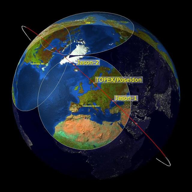
Altimeter Family Portrait: Topex/Poseidon, Jason-1 and OSTM/Jason-2
This image is a family portrait of Topex/Poseidon, Jason-1 and Ocean Surface Topography Mission/Jason-2...
JPL
Image
Dec 21, 2002
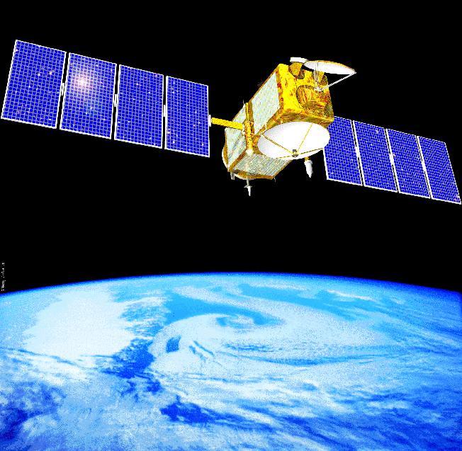
Artist Concept of Jason 1
Artist concept of NASA's Jason 1 spacecraft from December, 2002. http://photojournal.jpl.nasa.gov/catalog/PIA04237
JPL
Image
Mar 26, 2009
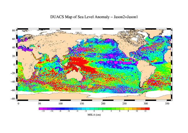
First Jason-1 and OSTM/Jason-2 Tandem Global View
This is the first global map of ocean surface topography produced with data from the new interleaved tandem mission...
JPL
Image
Apr 27, 2009
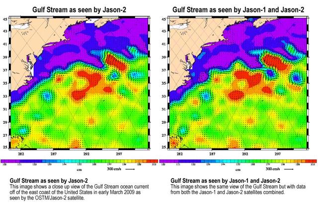
OSTM/Jason-2 and Jason-1 Tandem Mission View of the Gulf Stream
Created with altimeter data from NASA's Ocean Surface Topography Mission (OSTM)/Jason-2 satellite and the Jason-1...
JPL
Image
Oct 17, 2012
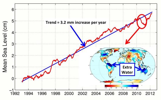
After Brief Dip, Global Mean Sea Level Resumes Climb
This figure shows changes in global mean sea level as measured by satellite altimetry NASA/CNES Topex/Poseidon and...
JPL
Image
Dec 13, 2008
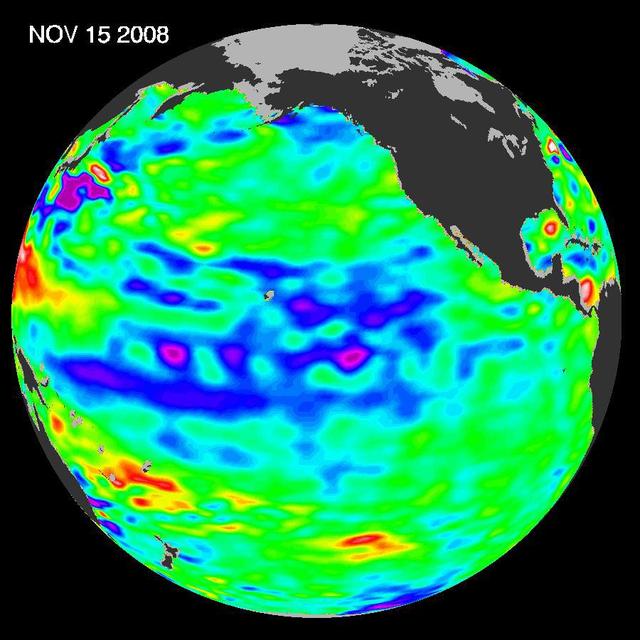
Oscillation Rules as the Pacific Cools
The latest image of sea-surface height measurements from NASA U.S./French Jason-1 oceanography satellite shows the...
JPL
Image
Oct 21, 2005
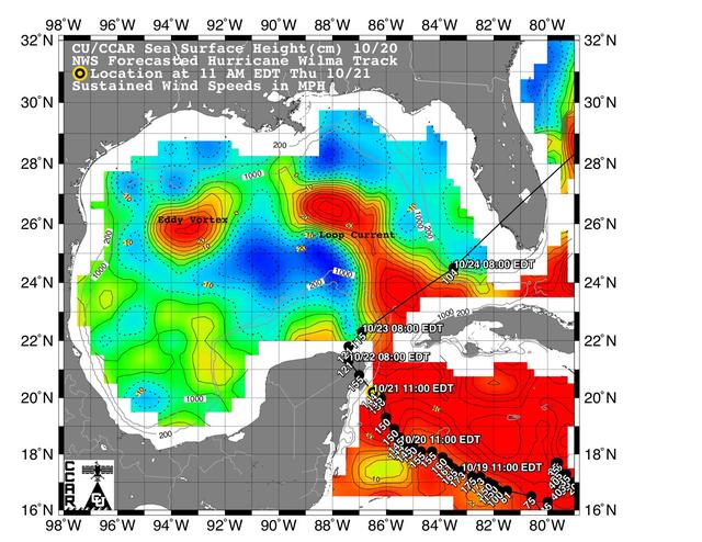
Wilma Trek Through Warm Caribbean/Gulf Waters
This sea surface height map of the Gulf of Mexico and the northwestern Caribbean Sea, with the Florida peninsula on...
JPL
Image
Dec 7, 2006
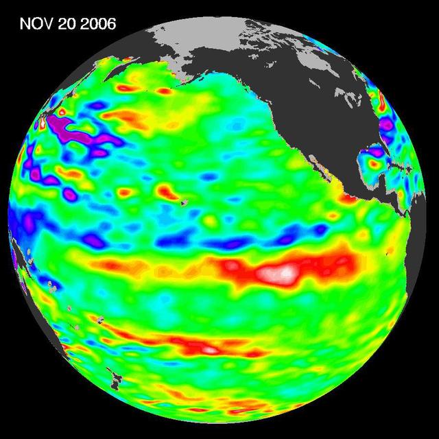
Jason Celebrates 5th Anniversary as El Niño Builds, Warm Kelvin Wave Surges Toward South America
Recent sea-level height data from NASA Jason-1 altimetric satellite show that continuing weaker-than-normal trade...
JPL

Image
Dec 12, 2013
1301253
JASON ELDRIDGE, AN ERC INCORPORATED EMPLOYEE SUPPORTING THE MATERIALS & PROCESSES LABORATORY AT NASA'S MARSHALL...
MSFC
Image
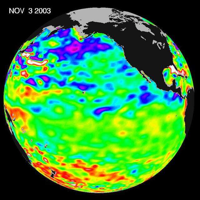
Nov 18, 2003
A Mostly Quiet Pacific
Some climate forecast models indicate there is an above average chance that there could be a weak to borderline El...
JPL

Image
Nov 17, 2021
SpaceX Crew-1 Postflight
SpaceX Crew-1 NASA astronauts, from left to right, Shannon Walker, Victor Glover, Mike Hopkins, and Japan Aerospace...
HQ
Image
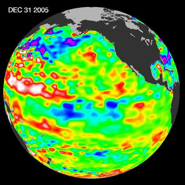
Jan 13, 2006
She Back? La Niña Developing?
The tropical Pacific Ocean is beginning to exhibit the characteristics of a developing La Niña condition.
JPL
Image
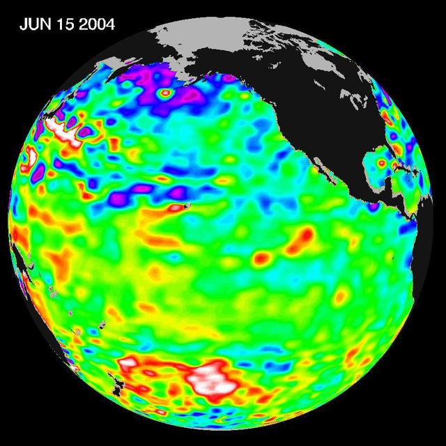
Jul 13, 2004
Pacific Decadal Oscillation Influences Drought June 15, 2004
Recent sea level height data from NASA U.S./France Jason altimetric satellite during a 10-day cycle ending June 15,...
JPL
Image
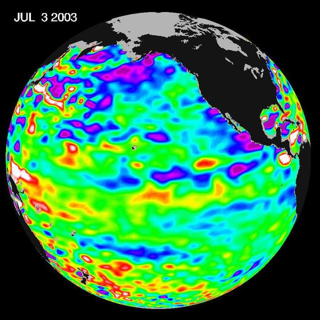
Jul 14, 2003
Where is La Niña?
Since the weak El Niño event of last winter, the equatorial Pacific has cooled and oceanographers have been on a La...
JPL
Image
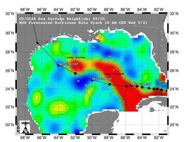
Sep 22, 2005
Rita Roars Through a Warm Gulf September 22, 2005
This sea surface height map of the Gulf of Mexico, with the Florida peninsula on the right and the Texas-Mexico Gulf...
JPL
Image
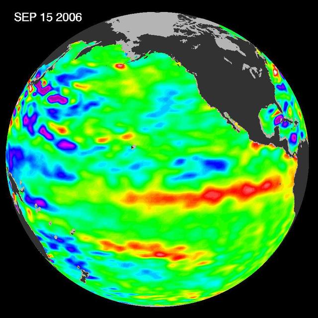
Oct 10, 2006
Jason Satellite Observes Mild El Nino in 2006
In September 2006, NASA satellite data indicated that El Niño had returned to the tropical Pacific Ocean, although...
JPL
Image
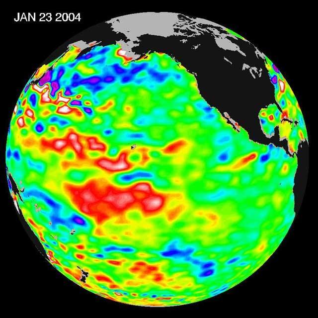
Jan 30, 2004
Pacific Dictates Droughts and Drenchings
The latest remote sensing data from NASA's Jason satellite show that the equatorial Pacific sea surface levels are...
JPL
Image
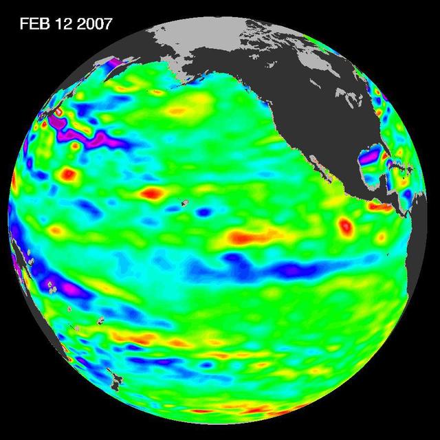
Mar 2, 2007
Pacific Shows Signs of Morphing From Warm El Nino To Cool La Nina
New data of sea-level heights from early February, 2007, by the Jason altimetric satellite show that the tropical...
JPL
Image
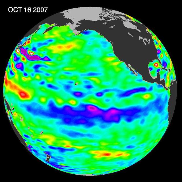
Nov 7, 2007
La Niña Persists
The tropical Pacific Ocean remains in the grips of a cool La Niña, as shown by new data of sea-level heights from...
JPL
Image
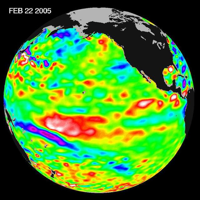
Mar 14, 2005
El Niño: The Weak, Getting Weaker
Recent sea-level height data from NASA U.S./France Jason altimetric satellite during a 10-day cycle ending February...
JPL
Image
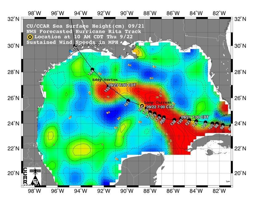
Sep 21, 2005
Rita Roars Through a Warm Gulf September 21, 2005
This sea surface height map of the Gulf of Mexico, with the Florida peninsula on the right and the Texas-Mexico Gulf...
JPL

Image
Sep 26, 2005
NASA Data Helps Track Heat Potential Fueling Rita
Tropical Cyclone Heat Potential TCHP field in the Gulf of Mexico during September 22, 2005. The path of Hurricane...
JPL
Image
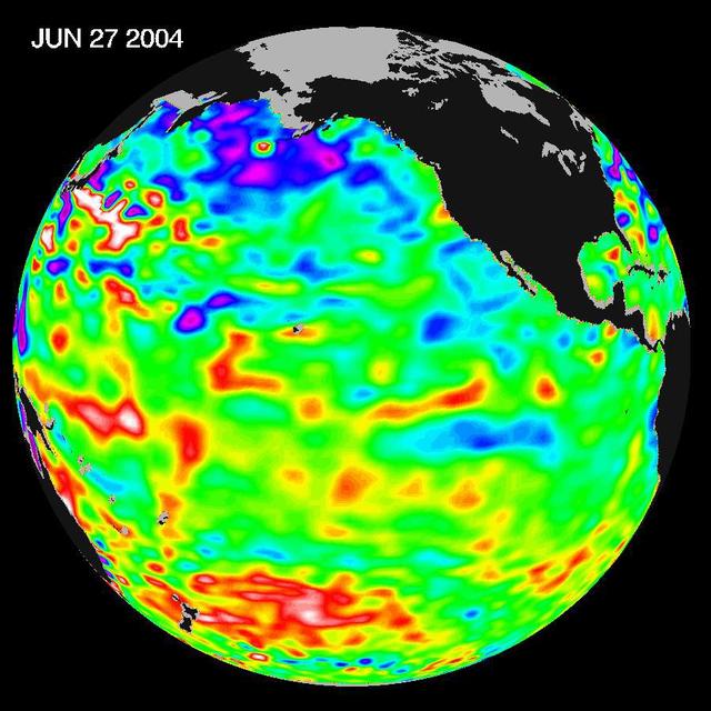
Jul 13, 2004
Pacific Decadal Oscillation Influences Drought June 27, 2004
Recent sea level height data from NASA U.S./France Jason altimetric satellite during a 10-day cycle ending June 27,...
JPL
Image
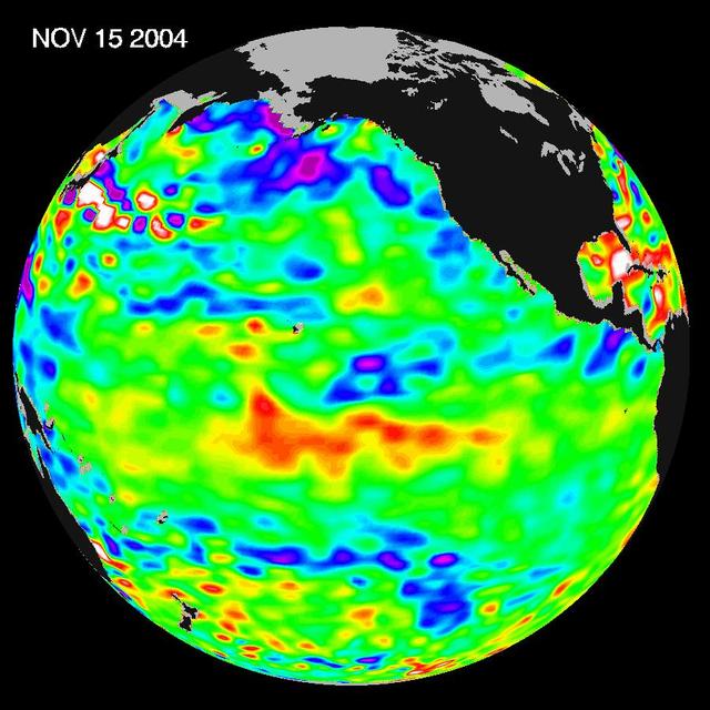
Nov 16, 2004
El Nino: Pumping Up or Fizzling Out?
Recent sea-level height data from NASA U.S./France Jason altimetric satellite during a 10-day cycle ending November...
JPL