
Image
Jan 26, 2024
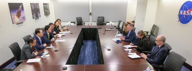
NASA and Mongolia Meet to Discuss Space Strategy and Disaster Mo
Associate Administrator Jim Free, talks with Mongolian Minister of Digital Development and Communications Nyam-Osor...
HQ
Image
Oct 7, 2025
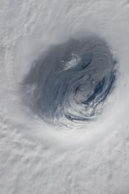
iss073e0875899
iss073e0875899 (Oct. 7, 2025) --- Typhoon Halong as captured from the International Space Station showcasing its...
JSC
Image
Jan 26, 2024
NASA and Mongolia Meet to Discuss Space Strategy and Disaster Mo
Associate Administrator Jim Free, 3rd from right, and the Mongolian Minister of Digital Development and...
HQ
Image
Oct 13, 2009
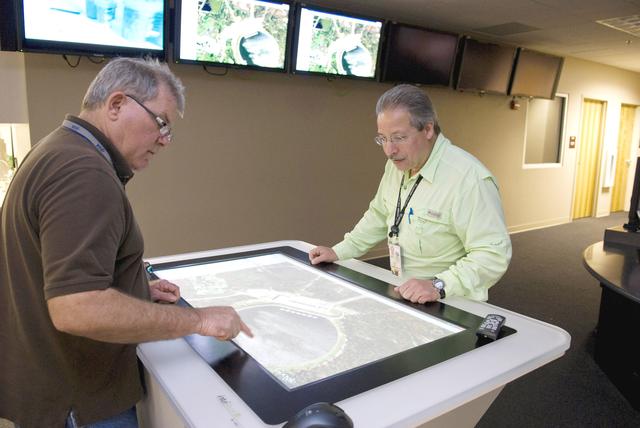
Stennis all-hazards network adopted throughout NASA
Stennis Space Center employees Mike McKinion (left), with Erica Lane Enterprises, and Luke Scianna, with the Jacobs...
SSC
Video
Aug 27, 2012
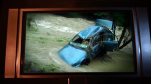
GPM Applications: Too Much Too Little
Water is fundamental to life on Earth. Knowing where and how much rain and snow falls globally is vital to...
GSFC
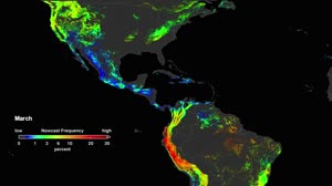
Video
Mar 22, 2018
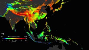
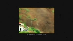
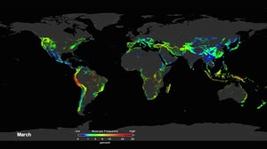
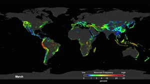
NASA Landslide Model: Southeast Asia
A new model has been developed to look at how potential landslide activity is changing around the world. A global...
GSFC
Video
Mar 22, 2018
New NASA Model Finds Landslide Threats in Near Real-Time During Heavy Rains
A new model has been developed to look at how potential landslide activity is changing around the world. A global...
GSFC
Video
Mar 22, 2018
NASA Landslide Model: Global
A new model has been developed to look at how potential landslide activity is changing around the world. A global...
GSFC
Video
Mar 22, 2018
NASA Landslide Model: Global 2
A new model has been developed to look at how potential landslide activity is changing around the world. A global...
GSFC
Video
Mar 22, 2018
NASA Landslide Model: Americas
A new model has been developed to look at how potential landslide activity is changing around the world. A global...
GSFC
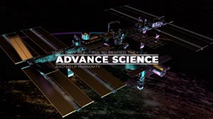
Video
Jul 25, 2022
Seeing Our Home in a Whole New Light: Space Station Benefits
From its orbit 400 kilometers (250 miles) above Earth, the International Space Station collects a variety of data...
HQ

Video
Apr 12, 2013
GPM: Our Wet Wide World
The Global Precipitation Measurement (GPM) is an international satellite mission to provide next-generation...
GSFC
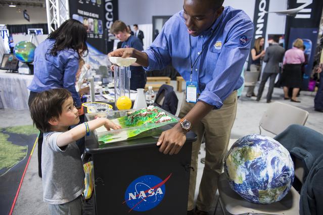
Image
Apr 25, 2014
USA Science and Engineering Festival 2014
A NASA staff member describes the Global Precipitation Measurement Mission. The GPM Core Observatory satellite was...
HQ

Video
May 15, 2012
GPM: The Fresh(water) Connection
The Global Precipitation Measurement (GPM) is an international satellite mission to provide next-generation...
GSFC

Image
Apr 25, 2014
USA Science and Engineering Festival 2014
A NASA staff member describes the Global Precipitation Measurement Mission. The GPM Core Observatory satellite was...
HQ
Video
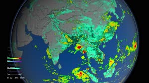
Jun 23, 2016
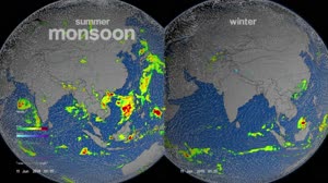
Monsoons: Wet, Dry, Repeat...
The monsoon is a seasonal rain and wind pattern that occurs over South Asia (among other places). Through NASA...
GSFC

Image
May 27, 2014
White House Science Fair
Girl Scout troop 2612 members from Tulsa, OK take photos of one another with Google Glass at the White House Science...
HQ
Video
Apr 27, 2018
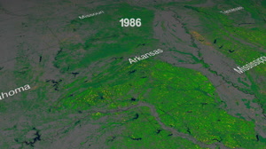
25 Years of Forest Dynamics
Forests are living, ever changing ecosystems, affected by aging, natural disasters and human interventions. Annual...
GSFC

Video
Apr 19, 2017
NASA's Vantage Point to View Earth
No planet is better studied than the one we actually live on. NASA's fleet of 26 Earth science spacecraft, supported...
GSFC
Video
May 16, 2016
Monsoons: Wet, Dry, Repeat... Abridged Version
The monsoon is a seasonal rain and wind pattern that occurs over South Asia (among other places). Through NASA...
GSFC
Video
Aug 27, 2012
GPM Applications: Tropical Cyclones
Water is fundamental to life on Earth. Knowing where and how much rain and snow falls globally is vital to...
GSFC
Image
Oct 5, 2016
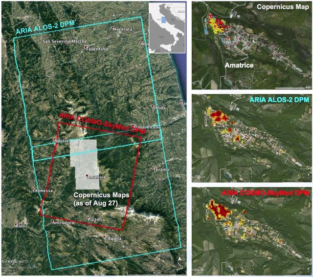
NASA-Produced Maps Help Gauge Italy Earthquake Damage
A NASA-funded program provided valuable information for responders and groups supporting the recovery efforts for...
JPL
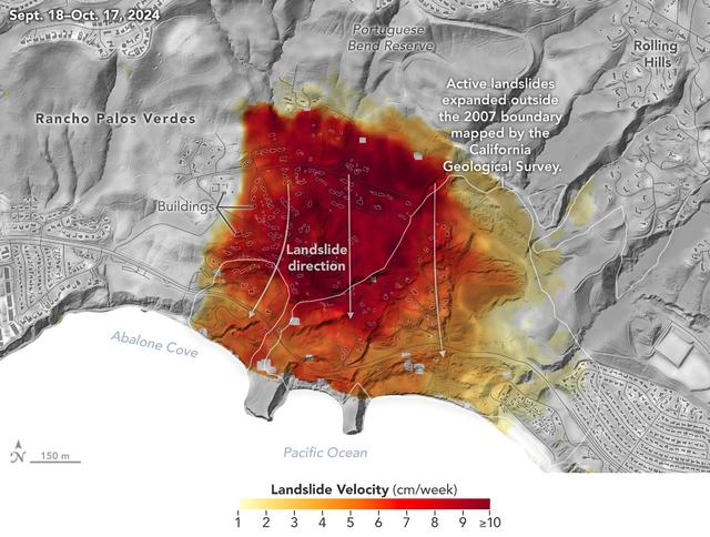
Image
Jan 31, 2025
NASA Radar Looks at Palos Verdes Landslides
Researchers at NASA's Jet Propulsion Laboratory in Southern California used data from an airborne radar to measure...
JPL
Image
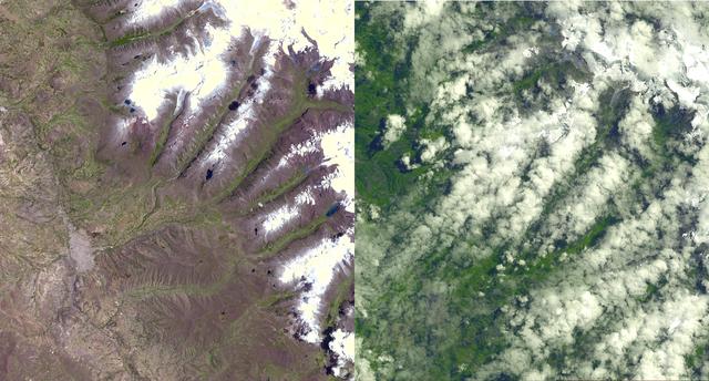
Apr 11, 2003
NASA Keeps Watch on a Potential Disaster in the Icy Andes
An Earth-monitoring instrument aboard NASA's Terra satellite is keeping a close eye on a potential glacial disaster...
JPL