Mars Boulders: On a Hill in Utopia Planitia
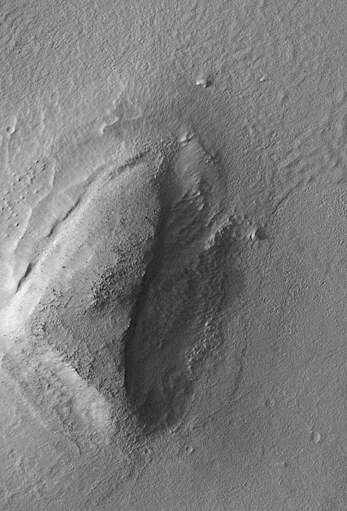
The Mars Global Surveyor (MGS) Mars Orbiter Camera (MOC) was designed specifically to provide images of Mars that have a resolution comparable to the aerial photographs commonly used by Earth scientists to study geological processes and map landforms on our home planet. When MGS reaches its Mapping Orbit in March 1999, MOC will be able to obtain pictures with spatial resolutions of 1.5 meters (5 feet) per pixel--this good enough to easily see objects the size of an automobile. Boulders are one of the keys to determining which processes have eroded, transported, and deposited material on Mars (e.g.,landslides, mud flows, flood debris). During the first year in orbit,MGS MOC obtained pictures with resolutions between 2 and 30 meters (7to 98 feet) per pixel. It was found that boulders are difficult to identify on Mars in images with resolutions worse than about 2-3 meters per pixel. Although not known when the MOC was designed,"thresholds" like this are found on Earth, too. The MOC's 1.5 m/pixel resolution was a compromise between (1) the anticipation of such resolution-dependent sensitivity based on our experience with Earth and (2)the cost in terms of mass if we had built a larger telescope to get a higher resolution. Some rather larger boulders (i.e., larger than about 10 meters--or yards--in size) have already been seen on Mars by the orbiting camera. This is a feat similar to that which can be obtained by "spy" satellites on Earth. The MOC image 53104 subframe shown above features a low, rounded hill in southeastern Utopia Planitia. Each of the small, lumpy features on the top of this hill is a boulder. In this picture, boulders are not seen on the surrounding plain. These boulders are interpreted to be the remnants of a layer of harder rock that once covered the top of the hill, but was subsequently eroded and broken up by weathering and wind processes. MOC image 53104 was taken on September 2, 1998. The subframe shows an area 2.2 km by 3.3 km (1.4 miles by 2.7 miles). The image has a resolution of about 3.25 meters (10.7 feet) per pixel. The subframe is centered at 41.0°N latitude and 207.3°W longitude. North is approximately up, illumination is from the left. http://photojournal.jpl.nasa.gov/catalog/PIA01500
Usage Rights
Most NASA images are in the public domain and free to use. Credit NASA as the source. Check NASA's media usage guidelines for details. Images featuring identifiable individuals may require additional permissions.
Keywords
Details
NASA ID
PIA01500
Date Created
September 18, 2000
Center
JPL
Media Type
image
Downloads
Download this image in multiple resolutions. All NASA media are free for public use.